


substi cap

mikaelerouzic
User

Length
45 km

Max alt
157 m

Uphill gradient
567 m
Km-Effort
52 km

Min alt
58 m

Downhill gradient
569 m
Boucle
Yes
Creation date :
2014-12-10 00:00:00.0
Updated on :
2014-12-10 00:00:00.0
1h40
Difficulty : Easy

FREE GPS app for hiking
 SityTrail
IGN / Geographical institutes
SityTrail Plus
The world is yours!
About
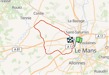
Trail Cycle of 45 km to be discovered at Pays de la Loire, Sarthe, Le Mans. This trail is proposed by mikaelerouzic.
Positioning
Country:
France
Region :
Pays de la Loire
Department/Province :
Sarthe
Municipality :
Le Mans
Location:
Unknown
Start:(Dec)
Start:(UTM)
287350 ; 5322390 (31U) N.
Comments